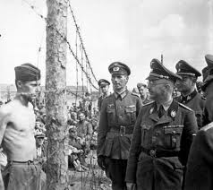
The first 64 POWs arrived in Stalag Luft 4 on May 14, 1944. In July 1944 a group of 3,200 prisoners came from Stalag Luft VI at Heydekrug. The majority of them were American, but also included were 800 R.A.F. non-commissioned officers.
The camp was situated in the center of a clearing of a dense pine forest. Prisoners who were transported by train arrived at Kiefheide Railroad Station. From there a short 2.75 km march brought them to Stalag Luft IV.
Update
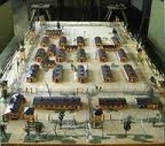
On May 22, 2007 we have updated the camp layout and exact location/orientation in the woods near Gr. Tychow. Thanks to Jeff Hanson for sharing this information with us.
We have projected the plan of Stalag Luft IV onto a 1:25.000 topographic map from 1936. The squares on the map are 1 x 1 km. The arrow points to Kiefheide railroad station.

Map extracts from Messtischblatt 2062 (1939) and 2063 (1936).
© Bundesamt für Kartographie und Geodäsie 2006.
In the following table we have entered the latitudes and longitudes (WGS84) of some interesting places of Stalag Luft 4 (not all on the map).

On the next map can be seen that Gr. Tychow is at 32 km South of Köslin (Koszalin), some 40 km from the Baltic Sea. Stalag Luft 4 was situated between Gr. Tychow and Kiefheide to the West.

Map extract from Polen, Planen & Touren, Übersichtskarte 1 : 1 000 000.
© Höfer Verlag 2006.
On the next, more detailed, map we have placed a rectangle at the location of Stalag Luft 4. We also underlined in red the places Kiefheide and Gr. Tychow. The railroad from Belgard (Bialogard) to the South-East will prove to be handy to find Kiefheide in Google Earth.

Map extract from Polen, HinterPommern PL003 1 : 200 000.
© Höfer Verlag 2006.
Google Earth
Unfortunately we are not allowed to reproduce how this area looks like in Google Earth. Despite the low resolution image, we can recommend you to launch the program anyway, as most points on the above map can clearly be distinguished in Google Earth.
Important Remark
Long time after we finished this page we found out that it is much easier to enter the co-ordinates of a point in the “Fly to” box in Google Earth. Enter “53 56 30 N, 16 10 59 E” (without the quotes) for Stalag Luft 4 and zoom out far enough to see the whole picture.
Original text
Start Google Earth. In the upper left box “Fly to” type “Bialogard Poland” (without the quotes). Google Earth zooms in to an Eye Alt of about 3400 ft, which does not make sense with this low resolution image. With the wheel on your mouse choose an “Eye Alt” (lower right corner of the screen) of about 25 mi. Drag the image a little to the left and a little up (Kiefheide is to the SE). In Layers activate “Railroads”. Follow the railroad to the SE till you see a clear spot, just South of the railroad in the middle of dark green forests. This is Kiefheide. If you drag this spot to the middle of your screen, you can zoom in to about 34 000 ft. Uncheck “Railroads” in Layers, as it only disturbs at this zoom level. In the lower left corner of the screen you can read the latitude and longitude of the pointer. With the values in the above table with latitudes and longitudes, you will be able to find all those places.
Next small map can probably help you with your search in Google Earth.

Map extract from Polen, HinterPommern PL003 1 : 200 000.
© Höfer Verlag 2006.
Evacuation of Stalag Luft IV
The following text is extracted from the 303rd Bomb Group (H) Association website.
On January 28, 1945 a train load (mostly sick and wounded) were taken to Stalag Luft 1 at Barth, Germany and on February 2, 1945 another train load was taken to Stalag XIIID at Nürnberg, Germany. In February 1945 the Russian offensive threatened to engulf Stalag Luft 4. On February 6-7-8, 1945 about 6,000 prisoners were ordered to leave the camp on foot with only a few hours notice. It was a march of great hardship. The POWs, in groups of 250 to 300, were marched long daily distances on starvation rations.
The initial portion of the march ended on March 30, 1945 near Hannover, Germany. The men were then transported in box cars to Stalag IIB near Hammerstein/Schlochau (Czame/Czluchow). They were then forced to make a second march on April 6th that doubled back on their earlier route. The main column encountered British troops on May 2, 1945. East of Hamburg. The “Death March,” from beginning to end, spanned 86 days over an estimated 600 miles.
Map Source: Höfer Verlag 2006, Article Source GPS-practice-and-fun.com