Thorn in 1940
Stalag 20A was situated at many places. Although they date from the late 19th century, only 2 of the 17 forts are visible on the 1929/1940 map of Thorn, but not mentioned as such. They are forts III and XVI. We have indicated the positions of all 17 forts and it can easily be seen that in 1940 the whole town of Thorn still fitted nicely within the ring of forts.
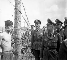
In late 1939 Polish POWs were held in the forts of Thorn. They converted forts XI to XVII to prisons. Forts XI, XII and XIII held British POWs. Fort XIV was the camp hospital and fort XV held French POWs. The Headquarters of the camp was in fort XVII, until mid 1940, when a two-story house opposite fort XIII, now in Okolna Street, was taken over.

Map extract from Messtischblatt 2977 (1940), 2978 (1940), 3077 (1929) and 3078 (1929).
© Bundesamt für Kartographie und Geodäsie 2006.
Ring of forts
It is interesting to see how the forts were situated and how they were numbered. Counter-clockwise. We do not know the significance of this numbering (if any).

Stalag 312
All forts South of the river Weichsel (Wisla), except fort X, which was the “Bateria”, were used as prisons and together they were called “Stalag 312”.

Map extract from Messtischblatt 2977 (1940) and 3077 (1929).
© Bundesamt für Kartographie und Geodäsie 2006.
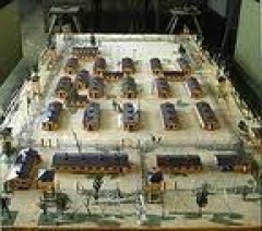
Camps 13
When we further zoom in on our “before war” map, we come to an extract from 1929. Here we can see that already in 1929 there was a barracks camp on the site.

Map extract from Messtischblatt 3077 (1929).
© Bundesamt für Kartographie und Geodäsie 2006.
Russian POWs
During the second half of 1941 new barracks were built in the direction of Glinki to accommodate Russian POWs. We have not found a camp layout, nor aerial photograph of the new Stalag 20A barrack camps.
Latitudes and Longitudes for Stalag 20A
In the following table we have indicated the co-ordinates (WGS84) of all 17 forts with their actual Polish names. We also indicated the latitudes and longitudes of camps 13A and 13B of Stalag 20A and two cemeteries.
Very interesting are also two blocks with 3 long parallel barracks each, which we called B1 and B2 (see arrows). In Google Earth can clearly be seen that the 3 barracks of B2 are still there and that the 3 barracks of B1 probably are pulled down only recently, as their forms can still be seen on the soil.

Projection on an actual map of Torun
On the following map can be seen that Torun does not fit within the circle of forts anymore. It expanded in the NE direction and also in the SW direction to Cierpice (Schirpitz).

Map extract from N-34-97/98 and N-34-109/110 1 : 100 000.
© Mapa topograficzna Polski (MTP) 2006.
Google Earth
Unfortunately we are not allowed to reproduce how this area looks like in Google Earth, but the high resolution imagery of the region make it worth the exercise to play with Google Earth.
Important Remark
Long time after we finished this page we found out that it is much easier to enter the co-ordinates of a point in the “Fly to” box in Google Earth. Enter “52 59 31 N, 18 35 51 E” (without the quotes) for Stalag 20A and zoom out far enough to see the whole picture.
Original text
Start Google Earth. In the upper left box “Fly to” type “Torun Poland” (without the quotes). Google Earth zooms in to an Eye Alt of about 3500 ft, so you can immediately appreciate the high resolution. In Layers do NOT check “Google Earth Community” and do NOT check “i Google Earth Community (unranked)”.
With the wheel on your mouse, zoom out to an Eye Alt. of about 11 mi (lower right corner of the screen). What catches the eye, and what was not visible on the previous maps, are the works for a motorway South of Torun. Thanks to the high resolution of the images, you can zoom in to an Eye Alt. of 1000 ft. But to find the 17 forts for the first time, you will probably need the latitudes and longitudes from the above table. You can read the co-ordinates of the pointer (a small hand) in the lower left corner of the screen.
The End
When early January 1945 the Russian troops advanced from the East, the prisoners of Stalag 20A were marched out into Germany, through a Polish winter, sleeping in the open and eating pig swill to survive. Many men died during this march. The survivors were finally liberated by the Americans, far in Germany. Fort XIV, the camp hospital, was liberated by the Russians on January 21, 1945.
The cemetery of Stalag 20A
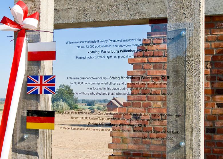
Over 60 000 inmates were processed through Stalag 20A over a period of five years, including Poles, French, Belgians, British, Yugoslavs, Russians, Norwegians, Italians and Americans. British POWs were buried in the garrison military cemetery (we found cemeteries next to forts XI and XVI), while Russian POWs were buried in a mass grave in the forest near Stalag 312, between Glinki and Cierpice. About 14 000 men are buried there.
Where is Torun?
On a larger map of Poland, we can see where is Torun. We also indicated Stalags 1A Stablack, 1B Hohenstein and 20B Marienburg, in order to see where were other prisoners.

Map extract from Polen, Planen & Touren Übersichtskarte 1 : 1 000 000.
Höfer Verlag 2006 Source: GPS-practice-and-fun.com