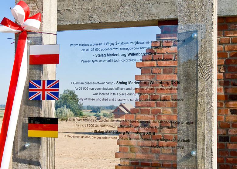
Finding Stalag 20B, another German WW II POW camp, has always been difficult. From 12/’39 till 02/’40 it was listed as being situated in Littschen-Marienwerder(Kwidzyn). From 02/’40 till 01/’45 it should have been situated at Marienburg (Malbork).
Part of Stalag 20B was in the Malbork Castle
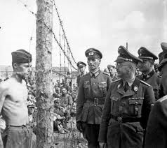
In Gdansk-Sightseeing-Malbork Poland-In Your Pocket we read: “During the war the castle served a mixture of purposes; the refectory was used for swearing in ceremonies for both Hitler Youth and troops marching to the Eastern Front, while another part of the castle was developed into Stalag XXB prisoner of war camp for commonwealth soldiers”. And indeed, we did see several photos with groups of POWs in front of very nice brick walls. So we have to believe that some prisoners were housed in the castle.
Where was Willenberg?
There must have been a main camp for Stalag 20B and often we read that it was in Willenberg. On a 1 : 25 000 topographic map from 1937 we indeed find Willenberg, at 3.4 km South of Malbork Castle along the river Nogat. There between the road to Marienwerder and the river is indicated on the map “Exerzier Platz” (Excercizing terrain). So, it is almost for sure that The Stalag 20B was located here.
Stalag 20B on an aerial photograph
For weeks we have searched for a layout of this camp, but did not find anything at all. On April 8, 2006 we finally found a small aerial photo with Stalag 20B, marked with a small white rectangle. This confirms that the main camp was at Willenberg.

Projected on our 1 : 25 000 map from 1937, it looks like this:

Map extract from Messtischblatt 1980.
© Bundesamt für Kartographie und Geodäsie 2006.
Jack Durey, who was transferred to the camp in December 1940 wrote: “Stalag XXB in Willenberg in East Prussia was the hutted camp, which had been used for the same purpose in World War I and was in poor condition”.
Another prisoner in the Willenberg camp was Stuart Brown, who wrote about it in his book ‘Forbidden Paths’. He spent a long time in a village opposite the camp where he took up with Dora, the farmer’s daughter. He brought her back home at the end of the war and settled in Edinburgh. They visited the area in the 1970’s at which time the camp had vanished without trace.
But there was another Stalag 20B
On October 9, 1943 USAAF B-17s bombed the Focke-Wulf assembly plant near Marienburg where half of all Fw-190’s, a one-engine German aircraft, were produced. See Aerial photo below.

B-17 Pilot Keith E. Harris (1919-1980) wrote later about these bombings:
“Well, it was a real good bombing; the accuracy was just outstanding. Practically all
the bombs were right inside the aircraft factory works and the buildings, and I heard
later on that there was even a POW camp right across the river–the river kind of
bends around this factory, and they didn’t get struck at all, and all of these bombs
landed very close, I suppose within 500 feet of the aiming point”.
What he did not know is that the river that bended around the factory was the Alte Nogat, a small branch of the Nogat, but when we look closer to the aerial photo, then we see in the upper right corner of the photo two barracks of the type as we have seen from an oblique, low altitude aerial photo of Stalag 1B. And these barracks are just across the river Nogat (see black arrow).
We have read about a small group of Belgian prisoners (about 200 persons) who were brought to a (small?) camp North East of Marienburg. So this could very well be another Stalag 20B. Anyway, if there were prisoners in that camp on the day of the bombing, they surely have noticed this, as they were only at a distance of 2 km.
Stalag 20B bis on our map
On our 1 : 25 000 topo map the two barracks show up as below.

Map extract from Messtischblatt 1980.
© Bundesamt für Kartographie und Geodäsie 2006.
Malbork Commonwealth War Cemetery
The Malbork Commonwealth War Cemetery is situated at the left side of the road from Marienburg (Malbork) to Marienwerder (Kwidzyn). Stalag 20B is situated at the right side of the same road, 2.75 km more to the South.

Map extract from Messtischblatt 1980.
© Bundesamt für Kartographie und Geodäsie 2006.
The Cemetery plan looks as follows. Probably the ditches along the road are filled up in the mean time.

In the following table we have entered the latitudes and longitudes (WGS84) of some interesting places.

The Malbork Castle
The war left the castle a skeletal heap of ruins; plundered by looters and abandoned by the state. It was only on January 1, 1961 that the Malbork Castle Museum was founded and restoration work given the green light; a mammoth effort finally rewarded in 1997 when the castle complex was added to the UNESCO world heritage list.
Google Earth
Unfortunately we are not allowed to reproduce how this area looks like in Google Earth. Thanks to the castle on the UNESCO heritage list, we find high resolution images in Google Earth. The castle alone makes the Google Earth visit a must. This is beautiful.
Important Remark
Long time after we finished this page we found out that it is much easier to enter the co-ordinates of a point in the “Fly to” box in Google Earth. Enter “54 00 31 N, 19 00 18 E” (without the quotes) for this camp and zoom out far enough to see the whole picture.
Original text
Start Google Earth. In the upper left box “Fly to” type “Malbork Castle” (without the quotes). Google Earth zooms in to an Eye Alt of about 3300 ft. In Layers do NOT check “Google Earth Community”. Only check “i Google Earth Community (unranked)”. The castle is in the lower left corner of your screen. Click on the “i” icon near the castle. Then “Click here for the post”. In the lower screen half click “Open this placemark”. Close the lower screen half. This is so beautiful.
To return to the previous image, click the search button in “Fly to” again. Drag the image to the NNE till you see a boat on the river Nogat. There on the East bank, on the other side of the road is the Malbork Commonwealth War Cemetery.
Drag the image further to the NE, following the river (you travel to the SW). Where the high resolution imagery ends was the former main camp of Stalag 20B.
With the wheel on your mouse zoom out to an Eye Alt. of about 20mi. Now you see to the right a small airport (in the low resolution part). Just North of it was the Focke-Wulf plant.
To the NW, just across the river Nogat, where the low and high resolution images meet, was situated Stalag 20B bis.
The End
In January 1945 the Red Army was closing in, and the Germans decided to evacuate all but the sick, the English doctors, padres and nursing orderlies. More than 8,000 men were assembled, and the huge column marched off westwards. Some who could not keep up were shot, some died of hypothermia, some of starvation, some of dysentery.
When the Russians attacked Marienburg, the hospital was evacuated, and the sick and the medical staff sought refuge from the shell and mortar fire in trenches in the grounds. In February, the medical staff set off with the wounded in a convoy of bicycles and horse-drawn carts, travelling south-east.
After three weeks, they reached Niedenburg, where they took a train to Odessa and eventually embarked on the troopship Duchess of Bedford.
How to get to Malbork (Marienburg)?
By far the most comfortable way would be to take a plane to Gdansk(Danzig) and travel the region in a rental car. See map below for an overview.

Map extract from Polen, Planen & Touren Übersichtskarte 1 : 1 000 000.
© Höfer Verlag 2006.
On the following map we see Malbork(Marienburg) and Kwidzyn(Marienwerder). Right of Malbork, at the border of this map, you can just see the small airport near the former Focke-Wulf plant. Willenberg is also indicated on this map.

Map extract from Polen, West-Ost-Preussen 1 : 200 000.
© Höfer Verlag 2006.
When you plan to travel to and in Poland, we highly recommend these bilingual maps (German/Polish) from Hoefer Verlag.
Map Source: Höfer Verlag 2006, Article Source GPS-practice-and-fun.com