For most of our readers Stalag 1A probably does not mean much. Situated at 54° 25′ N and 20° 32′ E in Ostpreussen (East Prussia), Stalag 1A was the most northern German POW camp of WW II.
Correction. From June 1943 till July 1944 there was a POW camp, Stalag Luft VI, for air force officers NE of Heydekrug (now Silute in Lithuania) near the actual village of Macikai at 55° 21′ N and 21° 31′ E.
After WW II the northern part of Ostpreussen became part of Russia (Kaliningradskaya Oblast) and was immediately hermetically sealed from the outside world as military protected area. All German names of cities, villages and even streets were transformed to Russian names (see the names between parentheses below). The southern part of Ostpreussen became Polish territory. And Stalag 1A found itself just a few kilometers from the Polish – Russian border, on Russian territory.
Until the collapse of the USSR in August 1991 no-one ever had been able to return to the grounds of Stalag 1A or the cemetery for prisoners of war at Klein Dexen. This is the reason why Stalag 1A has always remained the most mysterious German POW camp of WW II.
History of Stalag 1A
In 1934 the Germans arranged a 10.000 ha big military exercise area in the Stablack region west of Preussisch Eylau (Bagrationovsk) and south of the (new) railway Preussisch Eylau – Stablack – Zinten(Kornevo) – Heligenbeil(Mamonovo). In 1935 they started building the garrison city of Gartenstadt Stablack(Dolgurokovo) about 1 km north of the railway on 50 ha land from the farm-village Waldkeim. In 1939 Gartenstadt Stablack had a population of 2.730, principally military personnel.
In the mean time they also started building the barracks for a garrison just south of the railway, north of the line Klaussen(Dubrovka) – Jerlaucken(Petrovskoe).
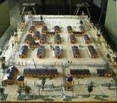
From September 1939 on, Polish prisoners of war were transported to the garrison where they were housed in tents. They were the ones who erected the 40 barracks for POWs plus several auxiliary barracks for Stalag 1A on a 30 ha piece of land north of the railway, opposite to Klaussen(Dubrovka) and east from Stablack railway-station.
But where was it situated?
We have projected the plan of Stalag 1A onto a 1:25.000 topographic map from 1939 (see north of Klaussen). We also projected the actual Russian-Polish border on this map (the black line near the bottom). The squares on the map are 1 x 1 km.

Map extracts from Messtischblatt 1589 and 1689.
© Bundesamt für Kartographie und Geodäsie 2006.
In the following table we have entered the latitudes and longitudes (WGS84) of some interesting places for Stalag 1A (not all on the map).

On our GPS76 it looks like this:

This is interesting, because it shows that one of the rare actual border crossings, the one SE of Bagrationovsk (Preussisch Eylau), is only a few kilometers away. Over the road from this point to the Stablack railway station, near Stalag 1A, is about 15km. If you would like to visit the cemetery of Klein Dexen, please inform yourself, because for these few kilometers on Russian soil, you will need a visa and special insurances and everything is indicated in Russian, worse yet, in Russian with Cyrillic characters. And it will be hard to find someone who speaks or even understands English, German or French.
Google Earth
Unfortunately we are not allowed to reproduce how this area looks like in Google Earth. Despite the low resolution image, we can recommend you to launch the program anyway, as most points on the above map can clearly be distinguished in Google Earth.
Important Remark
Long time after we finished this page we found out that it is much easier to enter the co-ordinates of a point in the “Fly to” box in Google Earth. Enter “54 24 59 N, 20 32 15 E” (without the quotes) for Stalag 1A and zoom out far enough to see the whole picture.
Original text
Start Google Earth. In the upper left box “Fly to” type “Bagrationovsk Russia” (without the quotes). With the wheel on your mouse choose an “Eye Alt” (lower right corner of the screen) of about 30.000 ft. Drag the image a little to the right and a little down. In the lower left corner of the screen you can read the latitude and longitude of the pointer. If you move the pointer (a little hand) so that you read “Pointer 54°24’58.80 N 20°32’15.09 E”, you are at Stalag 1A.
Better imagery now
In January 2008 we saw that in the meantime Google Earth has way better imagery in place for this camp. We can now see that the road that crossed the camp is still there. We see the railway station building at 54° 25′ 01.08″ N, 20° 31′ 28.02″ E. And even the memorial at the former Klein-Dexen cemetery can be distinguished at 54° 23′ 28.62″ N, 20° 33′ 04.28″ E.
History continued
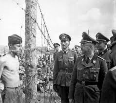
End 1939 some 47.000 Polish POWs were registered at Stalag 1A. Most of them have left the camp in 1940 and 1941. End May 1940 the first Belgian POWs arrived, soon followed by French prisoners. In 1940 some 23.000 Belgian and some 35.000 French prisoners were registered in the camp. In 1941 arrived another 2.500 French and about 1.000 Russian prisoners. Most prisoners would stay till the end of WW II.
What did they do all day?
The prisoners were not locked up in their barracks. Most of the time they did not even stay in Stalag 1A, but worked in the fields or some even in factories, spread over the whole North Ostpreussen territory. In order to organize things, Stalag 1A had 23 command posts over North Ostpreussen. Prisoners were lodged there for more or less longer periods of time and worked during the day.
And at the end?
Maybe it is high time to add a map of Ostpreussen. This was the situation before WW II (although the later separation line is already drawn in).

Already in October 1944 the Red Army stood at the borders of Ostpreussen, but could be stopped. The Russians used the last two months of 1944 to reorganize and to supply their troops. As the German leadership in Berlin kept saying that foreign troops would not be able to penetrate the German territory, Christmas 1944 in Ostpreussen was calm and peaceful, like the years before.
But in January 1945 all hell broke loose. From the North, the East and the South Russian troops stormed into Ostpreussen. In the first contacts with the German civilian population they acted barbarian, as a revenge for the brutal way that SS-troops had operated in Russia before. They raped, mutilated and killed every woman from 8 to 68. As soon as this news spread over Ostpreussen everyone wanted to leave the country at once. Endless tracks gathered on the roads, which were congested in no time. Many were rolled over by Russian tanks. In the heart of the winter at minus 25°C many died on the roads.
And our Stalag 1A prisoners of war?
Many of them, who worked for command posts in the eastern part of Ostpreussen suddenly found themselves behind the front lines. They were sent to Russia and only came home 6 months later after a very long trip through Europe. On January 25, 1945 Stalag 1A got the order to evacuate all prisoners, except the wounded, who would have to wait to be freed by the Russian army. Thousands of POWs, together with hundreds of thousands of civilians were directed to the West.
In the meantime the Russian army had reached Elbing from the south. The whole western part of Ostpreussen was now encircled. The only way out was over sea or over the narrow landstrip, the Friesche Nehrung, by crossing the frozen Frisches Haff. Endless columns of civilians with tracks and horses have taken this way, despite heavy bombardments by Russian aircraft, who tried to crack the ice with their bombs. Over 200.000 finally crossed the Frisches Haff.
In these last weeks of the battle of Ostpreussen the remaining German soldiers withstood heroically an overwhelming Russian army, only to give hundreds of thousands of civilians the chance to escape from the Russian barbarity. And equally brave were the crews of hundreds of marine and merchant vessels who evacuated 1.5 million civilians and more than 700.000 soldiers to the homeland. Several ships were sunk by Russian submarines. Several tens of thousands of children, women and wounded had not a single chance to survive in the cold Baltic Sea.
How to visit the grounds of Stalag 1A and the cemetery at Klein Dexen?
Preliminary Remark
We did not make the trip to Stalag 1A. What follows is based on the article of Robert Laack in http://www.bernsteinland.de/Main/Reisen_in_Ostpreussen/reisen_in_ostpreussen.html. Robert visited Kaliningradskaya Oblast 16 times. Not specifically Bagrationovsk. The article “Allgemeine Hinweise für Reisen ins nördlichen Ostpreussen” at www.ostpreussen-info.de affirms and completes this information.
As a tourist it is not advisable to travel into the area with your own car, unless you perfectly speak and understand the Russian language and writing. Especially in the border region you could have several controls of the police or the military. What’s more, your car insurance, valid in Poland, will not be valid in Russia, so you will have to take a special insurance coverage for this small trip.
Here is how we would (will?) arrange for this trip
First we will plan months ahead. We will need a visa in our passports. To obtain a visa, we have to prove that we have sufficient medical assurance for the duration of our stay (even if it is only a couple of hours).
Olsztyn (the former Allenstein) in the middle of the Mazurski lakes seems a nice place to stay for a couple of days. We would explain our hotel manager in detail about the trip that we want to make to the other side of the border and ask him to arrange a taxi with driver who is fluent in Russian and with whom we can communicate too. The taxi man must be allowed to pass the border with his cab and his passengers, of course.
From Olsztyn to the border at Bagrationovsk (the former Preussisch Eylau) is about 95 km. See map extract below.

Map extract from Polen, Planen & Touren, Übersichtskarte 1 : 1 000 000.
© Höfer Verlag 2006.
On the big day we will leave the hotel rather early in the morning, as it will probably be a long day. We prefer to take sandwiches and coffee from the hotel and will arrange a meal for our taxi driver too. We will explain our taxi man exactly what we want to visit and show him the map below (squares on the map are 2 x 2 km).

Map extract from N-34-53/54 Bagrationowsk 1 : 100 000.
© Mapa topograficzna Polski (MTP) 2006.
From the hotel to the border will be a one hour ride in our taxi. By the way, we will have to pay our taxi man by the hour, not by the distance traveled. Maybe American Dollars or Euros will be preferred for this. At the border we could loose up till three hours, unless the taxi man knows the Russian agents and can make it in one hour (all the paperwork and controls). Once we will have passed the border we travel in the direction of Bagrationovsk.
At the outskirts of Bagrationovsk we turn to the West and follow the direction Dolgorukovo. We follow the road till the point on the map, marked “Dubrowka I”. There we turn into the small road to the left. This small road led during WW II to the entrance of Stalag 1A. The grounds of Stalag 1A are now at our right. Here we will stop and try to enter the terrain on foot. You must feel this under your feet. If the weather is fine and there are not too many mosquitos, we will sit down and have our lunch here. Yes, we are romantics.
After lunch we continue our road, pass under the railroad and arrive at Dubrowka II where we turn to the right. We will have a look at the Stablack Railway Station and see if it still looks as on the photo below.

At Dolgorukovo we turn left and just after the chimney on our left we turn left again and will go straight to Furmanowo where we arrive at the spot were once was Klein Dexen. Just after the road crossings the former cemetery is on our right. Here we spend some time to think about the past and after another series of photos we continue in the direction of Nagornoje. There we turn to the right and we are back on the road to Bagrationovsk.
Hopefully the crossing of the border from Russia to Poland will go somewhat smoother than the other way around. Let’s count one hour. Another hour to return to our hotel in Olsztyn. So let’s count the hours: 1 from hotel to the border, let’s say 2 at the border, 3 on Russian soil, another 1 at the border and another 1 hour back to the hotel. So this will make it an 8 hour trip. A once in a lifetime trip.
Map Source: Höfer Verlag 2006, Article Source GPS-practice-and-fun.com