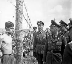
Stalag Luft 6 was by far the most northern German WW II POW camp. On lists with POW camps it is always indicated as having been open from 06/’43-07/’44, but this camp has a much longer history. It was built in 1939 as Stalag 1C. The first prisoners were of Polish nationality. In 1940 French and Belgian prisoners were brought to the camp and in 1941 also Russian prisoners.
It is only in June, 1943 that it became a Stalag Luft for enlisted men, when British and Canadian NCOs (non-commissioned officers) came to the camp from Stalag Luft I in Barth. The first Americans arrived in Stalag Luft 6 in February 1944. Already at that time the Russian Army advanced into the Baltic States from the North and the East. The main American group of 1,500 left the camp on July 14, 1944 and were transported, by train, to the Baltic Port of Memel (now Klaipeda in Lithuania). On board of the steamers “Masuren” and “Itsteburg” they crossed the Baltic Sea to the German port of Swinemünde (now Swinoujscie in Poland). From there they were brought to Stalag Luft IV by train. Another group went by train directly from Heydekrug to Stalag Luft IV. But this did not mean that Stalag Luft 6 was closed.
After the camp had fallen in Russian hands, German prisoners and Lithuanian dissidents and partisans were the new occupants of the camp. This time it became a concentration camp and even changed its name to GULAG 3. Even when WW II was over, GULAG 3 remained populated with “prisoners of war” till 1948. From 1948 till 1952 it served as prison for Lithuanian civilians.
Where was Heydekrug (Silute)?
As can be seen on the following map, Heydekrug was situated in Memelland, now Lithuania. On the map we also highlighted some other places: Bagrationovsk (Preussisch Eylau), where was situated Stalag 1A Stablack. Allenstein (Olsztyn) that we remember from our visit to Stalag 1B Hohenstein (Olsztynek)(not on this map), 25km SW of Allenstein. We also highlighted Ketrzyn. This was the former Rastenburg. Hitler spent most of the time during WW II in an enourmous bunker complex East from Rastenburg.

Map extract from Spectrum Wereldatlas.
© Uitgeverij Het Spectrum 1978.
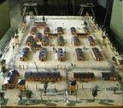
Stalag Luft VI 1km NE of Matzicken/Macikai
We have projected the plan of Stalag Luft 6 onto a 1:25.000 topographic map from 1914. The squares on the map are 1 x 1 km.

Map extract from Messtischblatt 0695.
© Bundesamt für Kartographie und Geodäsie 2006.
Macikai today
Matzicken/Macikai did not get famous because of Stalag Luft 6, but because of the German dramatist and novelist Hermann Sudermann, who was born in Gut Matzicken on September 30, 1857. There is today a small museum about Sudermann in one of the remaining buildings of the Gut.

Map extract from Nördliches Ostpreussen mit Memelland 1 : 200 000.
© Höfer Verlag 2006.
These bilingual Hoefer Verlag maps are invaluable for everyone who wants to do historic research in these areas. Highly recommended.
In the following table we have entered the latitudes and longitudes (WGS84) of some interesting places.

Google Earth
Unfortunately we are not allowed to reproduce how this area looks like in Google Earth. Three days after we published this page Google Earth replaced its low resolution image of the site with a much better resolution image. This is nice, because now we can see much more detail and most points on the above map can clearly be distinguished in Google Earth.
Important Remark
Long time after we finished this page we found out that it is much easier to enter the co-ordinates of a point in the “Fly to” box in Google Earth. Enter “55 21 22 N, 21 31 19 E” (without the quotes) for Stalag Luft 6 and zoom out far enough to see the whole picture.
Original text
Start Google Earth. In the upper left box “Fly to” type “Silute Lithuania” (without the quotes). This is the former Heydekrug. With the wheel on your mouse choose an “Eye Alt” (lower right corner of the screen) of about 28000 ft. Drag Silute to the left of your screen. Now you can clearly distinguish the new part of road 141 (in white), East of Silute, and the old road 165, also on the map from before WW II. You can also clearly distinguish the river Sziesze (Sysa). Once you have the center of Stalag Luft 6 in the center of your screen, you can zoom in to an Eye Alt. of about 13000 ft. With the help of our table of latitudes and longitudes and the pointer of Google Earth (lower left corner of your screen), you can find every spot of the former Stalag Luft 6.
The Stalag Luft 6 Cemetery
Many, many people died in the camp and they were buried outside the camp perimeter. Later the camp was cleared and the landscape purged of most traces of the camp. A visit by the U.S. consul in May 1993 resulted in a report stating that the cemetery now contains dozens of burial mounds, almost all unmarked, and what appears to be at least one mass grave. In the new Google Earth image can be seen some of the burial mounds, between the road NE of the camp and the river.
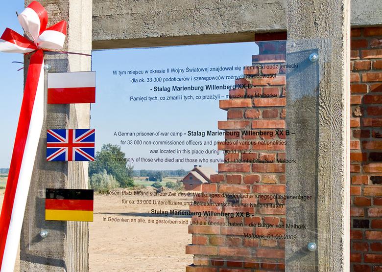
Concentration camp museum of Macikai
In 1991 the Macikai Authorities decided to fence in the whole area of the camp and in 1995 a museum was opened on the former camp grounds. Copies of archival documents, plans of the camp, various articles, lists and photographs of prisoners, journals and drawings are displayed in the former isolation cell.
How to get there?
We suppose that we managed to come to the town of Silute. We leave town by the main road in Eastern direction to Jurbarkas (Georgenburg) and Sowjetsk (Tilsit). After we crossed the rail road, we turn left in the direction of Zemaiciu (Naumiestis) (road 165). After another 1000m we reach the new road 141 and turn left. Here Macikai and the Sudermann museum are indicated. A little bit further we arrive at Gut Matzicken, where is located the Sudermann museum. One kilometer further, where the Teerstrasse bends to the right, we come to a huge Cross and burial mounds in the middle of heath and sand. The museum must be very close now.
Map Source: Höfer Verlag 2006, Article Source GPS-practice-and-fun.com