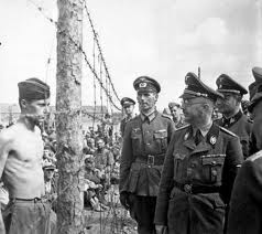
Stalag Luft 1 was opened end 1941 as a British Officer POW camp and was closed in April 1942 with British Officers moved to other POW camps. Reopened in October 1942 with transfer of 200 RAF NCOs from Stalag Luft 3. In 1943 also American POWs came to the camp. By the time of liberation the camp held 7 700 American Officers and 1 400 British POWs.
We have projected the plan of Stalag Luft 1 onto a 1:25.000 topographic map from 1927. The squares on the map are 1 x 1 km.

Map extract from Messtischblatt 1642.
© Bundesamt für Kartographie und Geodäsie 2006.
In the following table we have entered the latitudes and longitudes (WGS84) of some interesting places of Stalag Luft 1 (not all on the map).

The next map shows that Barth was situated in the extreme North of Germany, at the Baltic Sea. After WW II this part of Germany became the DDR (Eastern Germany). The red arrow indicates the location of Stalag Luft 1.

Barth Today
On the actual map of the Barth region we have indicated with a red arrow where the Memorial is situated.

Map extract from Mecklenburg-Vorpommern ADAC AutoKarte 1 : 200 000.
© ADAC 2006.
For GPS users: This map has an easy to use UTM grid printed on it.
Google Earth
Unfortunately we are not allowed to reproduce how this area looks like in Google Earth. On the high resolution image of the region, some traces from the past can still be distinguished.
Important Remark
Long time after we finished this page we found out that it is much easier to enter the co-ordinates of a point in the “Fly to” box in Google Earth. Enter “54 22 20 N, 12 41 42 E” (without the quotes) for Stalag Luft 1 and zoom out far enough to see the whole picture.
Original text
Start Google Earth. In the upper left box “Fly to” type “Barth Germany” (without the quotes). Google Earth zooms in to an Eye Alt of about 3300 ft. With the wheel on your mouse choose an “Eye Alt” (lower right corner of the screen) of about 11 mi. The grounds of Stalag Luft 1 are to the NW of the center of Barth. Drag this area to the center of your screen and zoom in to a level of about 6650 ft. Now we can recognize the situation, although not many traces from the past are left. At least two remarkable things can be found in the Google Earth image. First the long Western building of the Flak School and the memorial of Stalag Luft 1.
Evacuation of Stalag Luft 1
On April 30, 1945 the Senior American Officer (SAO) had several conferences with the Kommandant, who had orders to move Stalag Luft 1 to prevent it from falling into the hands of the Russians. The SAO stated that POWs would not move unless force was used, and the Kommandant finally agreed to avoid bloodshed. Late that night the Germans turned out the lights and left the camp, leaving the POWs behind. On May 1 a first contact was made with advanced Russian troops.
Although the actual liberation was performed by the Russians, no effort was made by them to evacuate the POWs from the area. There was even serious concern that these men were to be marched off to Russia. On May 6, 1945 Colonel Byerly, the former SAO, left Stalag Luft 1 with 2 officers of a British airborne division and flew to England the next day. After reporting to 8th Air Force headquarters on the conditions at the camp, arrangements were made to evacuate the liberated POWs by air.
On May 13, 1945 forty-one B-17G’s were sent from Bassingbourn in the UK to a runway near Barth in order to evacuate part of the prisoners. From Barth they immediately flew back to Leon airport near Bordeaux in France, where the ex-POWs were loaded on buses for Camp Lucky Strike. This operation was repeated on May 14 and completed on May 15.
Memorial
The Memorial at Stalag Luft 1 at Barth is beautifully landscaped with a large granite boulder sitting amidst a flower garden. On the boulder are two bronze plaques, one written in German, the other in English. To one side of the boulder are four flag poles flying British, American, Russian and the POW/MIA flags. Forming the apex of a triangle, there are three types of trees: American pine, British oak and Russian birch. This triangle can very well be distinguished in Google Earth.
Map Source: Höfer Verlag 2006, Article Source GPS-practice-and-fun.com